

Offshore seismic exploration generates enormous volumes of information, but collecting data is only part of the challenge. Moving that information from vessels operating hundreds of miles offshore to processing teams on land has historically required compromises involving bandwidth, latency, compression, or even physical transportation of storage media. Starlink TGS Seismic Data is changing that workflow by enabling high-bandwidth satellite connectivity between seismic vessels, cloud infrastructure, and onshore teams—even in some of the world's most remote maritime environments.
TGS, a global provider of energy data and intelligence, has integrated Starlink low Earth orbit connectivity into its marine seismic operations after testing the technology for high-volume offshore data transfer. TGS says its earlier workflow could require seismic data to remain onboard until it was physically shipped to an onshore facility because conventional satellite bandwidth was insufficient for transferring full datasets.
With Starlink, that limitation has changed substantially. TGS has successfully transferred full-integrity seismic datasets directly from vessels to the cloud, reducing delivery times and creating opportunities for near-real-time collaboration between offshore and onshore teams.
The capabilities behind Starlink TGS Seismic Data are particularly notable because they continue to operate at extreme northern latitudes. TGS has documented Starlink performance from vessels operating around 71° north—well inside the Arctic Circle—and has demonstrated multi-terabyte daily upload capacity in high-latitude waters.

How Starlink TGS Seismic Data Changes Offshore Exploration
Marine seismic surveys are highly data-intensive.
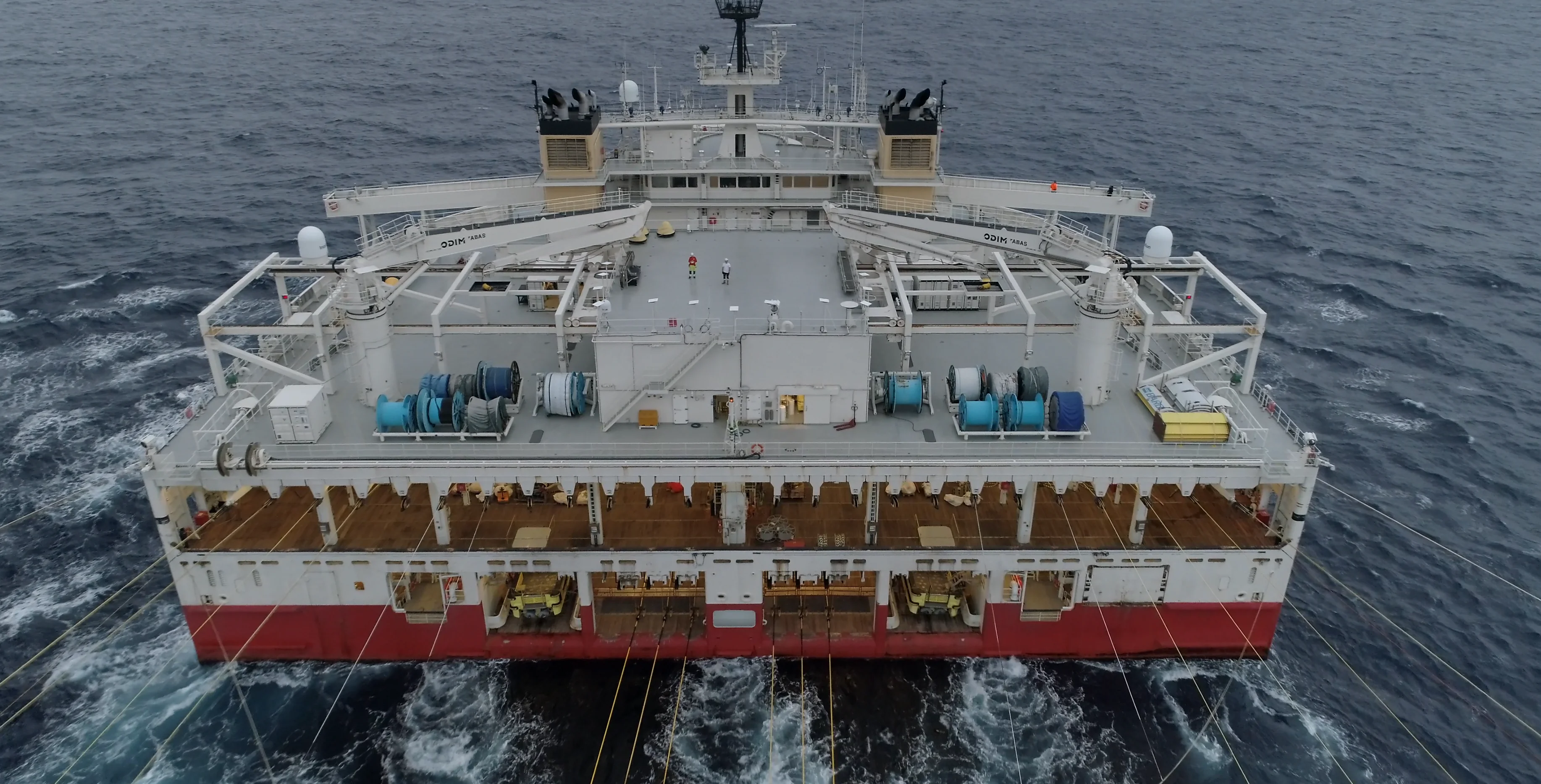
TGS operates specialized seismic vessels equipped to conduct 3D, 4D, and ocean bottom node surveys. Its fleet includes purpose-built Ramform vessels equipped with multisensor streamer technology, positioning systems, and sophisticated acquisition infrastructure.
As these vessels conduct surveys, they collect detailed subsurface information that can later be processed into images used for exploration, offshore development, carbon storage projects, and other geoscience applications.
Traditionally, moving those enormous datasets to land was difficult.
TGS explains that seismic data would first undergo quality control onboard the vessel and then remain stored there until it could be physically transported to an onshore processing facility. Satellite internet existed aboard vessels, but available bandwidth was not sufficient for immediate full-scale seismic data transfer.
Starlink TGS Seismic Data fundamentally changes this process by using high-bandwidth low Earth orbit satellite connectivity to begin transferring information while the vessel is still offshore.
From Physical Data Delivery to Direct Cloud Uploads
One of the clearest benefits of Starlink TGS Seismic Data is the reduction in data delivery time.
During testing in 2023, TGS successfully transmitted full-integrity 4D seismic data from two surveys directly into cloud infrastructure.
The result was dramatic: TGS reports that the data delivery time fell from an average of approximately nine days to just one day.
Instead of following a workflow resembling:
Sensor → Vessel Storage → Physical Transport → Onshore Facility → Processing
the new model can move toward:
Sensor → Vessel → Starlink → Cloud → Processing Team
That difference has major operational implications.
Onshore teams no longer necessarily need to wait for a vessel to reach port or for physical media to be transported before beginning important stages of the data workflow.
Why Low Earth Orbit Connectivity Makes the Difference
The technical foundation of Starlink TGS Seismic Data is Starlink's low Earth orbit satellite constellation.
Traditional geostationary satellite systems operate much farther from Earth. Although they have supported maritime communications for decades, their higher latency and bandwidth limitations have historically restricted certain data-intensive seismic applications.
TGS says low Earth orbit satellite technology provides increased bandwidth and lower latency, making near-real-time transfer of high-quality seismic data possible without the same reliance on data decimation or lossy compression.
This is particularly important because seismic datasets can be enormous.
TGS notes that imaging projects can involve datasets larger than 1 TB and potentially approaching 100 TB.
Moving information at this scale requires much more than ordinary vessel Wi-Fi.
Starlink TGS Seismic Data Works Deep Inside the Arctic Circle
The performance of Starlink TGS Seismic Data at extreme latitudes is one of the most interesting aspects of the deployment.
TGS has documented connectivity performance aboard vessels operating around 71° north, well within the Arctic Circle. During summer operations at approximately this latitude, TGS observed Starlink latency around 50–60 milliseconds.
TGS also tested data throughput aboard the Ramform Tethys while the vessel traveled from Lerwick toward waters northwest of Hammerfest.
Despite the challenging high-latitude environment, TGS reported throughput of approximately 15 GB per antenna per hour. Across the system, this translated into daily uploads exceeding 3.5 TB.
That is a significant amount of information to move from a vessel operating in remote northern waters.
Starlink states that its network provides connectivity across land, oceanic, and polar regions, except where service has not yet been authorized.
Multi-Terabyte Data Transfers at Sea
The Starlink TGS Seismic Data implementation has also demonstrated substantial throughput outside the highest latitudes.
TGS reports that a single Starlink subscription using a bonded pair of antennas can routinely transfer more than 500 GB within 24 hours. A single antenna has been observed uploading approximately 250–300 GB during the same period.
During another 2025 test, TGS evaluated a high-data-throughput service using between six and ten Starlink antennas while a vessel traveled between Angola and Las Palmas.
With ten antennas active, approximately 4.8 TB of data was uploaded within 24 hours.
These figures demonstrate why Starlink can support applications beyond conventional onboard communications.
For seismic operators, several terabytes per day can represent the difference between keeping data isolated onboard and integrating the vessel directly into a cloud-based processing workflow.
Real-Time Collaboration Between Vessels and Onshore Teams
Higher bandwidth changes more than transfer speed.
It changes how people can work together.
With Starlink TGS Seismic Data, specialists on land can gain access to offshore information much earlier in the acquisition process.
This creates opportunities for:
- Near-real-time quality control
- Remote technical collaboration
- Earlier data processing
- Faster troubleshooting
- Cloud-based analysis
- Project monitoring
- Faster client access
- More informed operational decisions
TGS says the technology has the potential to move some tasks onshore while also giving vessel crews stronger connections with teams on land.
This can effectively transform the seismic vessel from an isolated acquisition platform into a connected extension of the company's wider digital infrastructure.
Faster Seismic Data Can Mean Faster Decisions
The value of Starlink TGS Seismic Data becomes even clearer when considering what happens after acquisition.
Raw seismic information must undergo substantial processing before it becomes useful for interpreting subsurface geology.
This process can require high-performance computing and sophisticated imaging algorithms.
If the data cannot reach those computing resources quickly, the entire workflow is delayed.
By transmitting datasets directly into cloud infrastructure, processing can potentially begin sooner.
TGS says its cloud-native data ingestion pipelines can automate the reading, conditioning, ingestion, and indexing of seismic information. Data can then be made available through APIs for sharing, collaboration, and interoperability.
Connectivity therefore becomes part of the data-processing architecture itself.
Starlink and Cloud Computing Work Together
Cloud computing is another essential component of the Starlink TGS Seismic Data workflow.
Starlink provides the communications bridge between the vessel and terrestrial infrastructure, while cloud platforms provide scalable storage and computing resources.
Combining these technologies creates a continuous digital pipeline:
Offshore sensors → Vessel systems → Starlink → Cloud storage → HPC processing → Client access
TGS says its cloud transformation has reduced access times for certain datasets from weeks to less than an hour while enabling direct access at scale.
This represents a major departure from workflows built around physical storage media and isolated computing infrastructure.

Supporting Remote Research and Data-Intensive Maritime Operations
The use case also aligns closely with Starlink's broader maritime capabilities.
Starlink specifically identifies research vessels as a maritime application for its network, highlighting the ability to transfer data, upload images and video, perform real-time analysis, and maintain communications from remote areas.
These requirements closely resemble those faced by seismic operators.
A vessel collecting scientific or geophysical information may operate hundreds of miles from terrestrial broadband infrastructure while simultaneously producing terabytes of data.
The ability to upload information continuously creates new possibilities for remote ocean research, offshore energy operations, environmental monitoring, and other data-intensive maritime industries.
Connectivity Can Improve Vessel Operations Too
Although seismic data transfer is the headline application, Starlink TGS Seismic Data can support other vessel activities as well.
High-speed maritime internet can provide:
- Real-time weather information
- Video communication
- Remote technical support
- Cloud application access
- Operational monitoring
- Crew communications
- Software and data synchronization
Starlink's maritime platform is designed for global ocean connectivity and specifically supports applications such as real-time weather updates, monitoring, data transfer, image and video uploads, and remote analysis.
These capabilities can complement the dedicated seismic workflow while improving the vessel's broader digital environment.
Starlink Does Not Necessarily Replace Existing Satellite Systems
An important aspect of TGS's strategy is that Starlink does not automatically eliminate conventional maritime satellite communications.
Following its successful testing, TGS decided to implement a base Starlink LEO service alongside its existing VSAT geostationary satellite service.
The company treats the two systems as complementary, selecting connectivity based on factors such as bandwidth, latency, commercial terms, and the specific application.
This approach provides redundancy.
For critical offshore operations, maintaining multiple communication pathways can be more valuable than relying entirely on a single technology.
The Starlink TGS Seismic Data deployment therefore illustrates how LEO satellite broadband can be integrated into an existing enterprise communications architecture rather than simply replacing everything that came before it.
What This Means for the Future of Offshore Seismic Exploration
The larger significance of Starlink TGS Seismic Data lies in how connectivity changes the architecture of offshore work.
Historically, the vessel was both an acquisition platform and a temporary data island.
Information was collected offshore, stored offshore, and then moved physically before large-scale onshore processing could begin.
High-capacity satellite broadband changes that model.
A seismic vessel can increasingly function as a continuously connected node within a global cloud infrastructure.
Data can begin moving shortly after acquisition. Onshore teams can participate earlier. Processing can start sooner. Clients can potentially gain faster access to information.
TGS describes connected workflows enabled by LEO satellite technology as a new model for marine seismic data delivery, making near-real-time transfer and remote processing practical without the compromises previously required by limited bandwidth.

Building Reliable Starlink Systems for Remote Operations
TGS's implementation also demonstrates that professional Starlink installations involve more than the satellite terminal itself.
Data-intensive and remote deployments may require robust mounting, power systems, networking infrastructure, cables, adapters, and redundant connectivity equipment.
For Starlink installations in marine, vehicle, off-grid, remote-work, and enterprise environments, EDUP Starlink accessories provide mounting, cabling, PoE, networking, and power solutions for different deployment requirements.
For additional technical information about TGS's seismic operations, its official TGS seismic data and marine acquisition resources explain how the company acquires, processes, and delivers subsurface data worldwide.
Conclusion
Starlink TGS Seismic Data demonstrates how low Earth orbit satellite connectivity can transform an extremely data-intensive offshore industry.
TGS moved from a workflow in which seismic information often had to remain aboard a vessel until physical delivery to one where full-integrity datasets can be transmitted directly into cloud infrastructure. Initial testing reduced average data delivery time from approximately nine days to one day.
More recent operations demonstrate the scale the technology can achieve. TGS has documented multi-terabyte daily uploads and reliable Starlink performance at approximately 71° north, deep inside the Arctic Circle. During high-latitude testing aboard Ramform Tethys, daily upload capacity exceeded 3.5 TB.
The result is much more than faster internet aboard a ship.
Starlink TGS Seismic Data enables vessels, cloud infrastructure, processing teams, and clients to become part of the same connected workflow. Information can move sooner, specialists can collaborate remotely, and processing can begin without waiting for physical data transportation.
For industries operating in some of Earth's most remote environments, that represents a fundamental change: distance no longer has to mean digital isolation.


Leave a comment